TLC had a table at the Active Transportation Fair, Friday, May 30, at McMaster University where we handed out cycling route maps, and a tlc flyer. We also met other groups working on creating a sustainable transportation system including the HSR with a bus bike rack for people to try, MaCycle with their free bike tune-ups, GO transit, the city of Hamilton strategic planning department with a survey on rapid transit, and McMaster Security with free bike identification engraving.
Congrats to the organizers from McMaster's ACT office.
June 1-7, 2008 is the Commuter Challenge, you can find out more and register your participation here.
The week includes free HSR on Clean Air Day, Wednesday, June 4, if you have your wristband/bracelet, and participation (i.e. logging your daily commute) gets you a chance at a grand prize of VIA train tickets for two, anywhere in the Quebec-Windsor corridor.
Saturday, May 31, 2008
Thursday, May 29, 2008
never mind the bollards
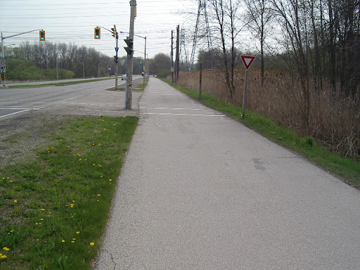
May 27, 2008
[Letter sent to city councillors Powers and McHattie, city cycling staff, and public works, also local media]:
Transportation for Liveable Communities (TLC) is a volunteer working group of the Ontario Public Interest Research Group at McMaster University. TLC seeks to improve conditions and infrastructure that supports and actively encourages healthy and sustainable transportation modes, including walking, transit, cycling and car pooling.
Earlier this month, a pedestrian and her dog were hit by a car which made a left-hand turn from Olympic Drive onto the Cootes cycling/pedestrian path. The car traveled nearly 2 kilometers on the path before hitting the pedestrian and her dog.
In light of this incident, and on behalf of TLC, I am writing to request a modest change to the intersection of Cootes and Olympic Drive in Dundas, namely in the intersection of Olympic Drive and the Cootes cycling/pedestrian path.
The intersection in question has no signs or barriers indicating that cars are not permitted on this path. Instead, there is a wide, paved section which leads from the road to the path, which can cause confusion for out-of-town or new-to-town individuals. (The former was the case with the above mentioned driver.) Signs indicating no motorized vehicles are only to be found once a person is actually on the path.
Due to this accident and the confusing opening to the Olympic Drive/Cootes path, TLC would like to request the installation of a soft, break-away style, yellow reflective bollard, at least 150cm tall installed in the centre of the paved section not closer than 100 cm to the edge of the Cootes path and at least 200 cm from the edge of the curb lane of Cootes Drive, along with an appropriate sign indicating no access for motor vehicles.
Thank you in advance for your assistance with this important pedestrian and cycling safety consideration.
Respectfully,
Anita TothTuesday, May 27, 2008
FRID REPLY
The City of Hamilton response to TLC concerns about transportation issues associated with the McMaster Innovation Park development.
RE: City of Hamilton
Frid Street, Schedule C
Class Environmental Assessment
Dear Mr. Dukas:
On behalf of the City of Hamilton, we would like to thank you for providing comments to PIC #2 for the above-noted study.
During and following PIC #2, the following comments were noted from the public:
- Improve accessibility for pedestrians;
- Consider “Safety First”;
- Provide for designated bicycle lanes;
- Provide landscape/urban design boulevards;
- “Do it right the first time”; and,
- Retain and provide accessibility for Historic Power Plant.
In response to these comments, the City of Hamilton indicated that the preferred design alignment and cross-section for the Frid Street extension be modified to take into consideration comments provided by the public during the Public Consultation process.
For the existing section of Frid Street between Main Street and Chatham Street, the 23m right-of-way (ROW) identified in the Kirkendall Neighbourhood Traffic Management Plan (TMP) remains as this is an existing developed area.
For the new section of Frid Street between Chatham Street and Longwood Road, the City and landowners have agreed that 26m right-of-way be provided to incorporate designated bike lanes, sidewalks on both sides and wider boulevards as requested by the public.
In the Schedule C Environmental Study Report (ESR), the following typical cross-section for the existing section of Frid Street between Main Street and Chatham Street (23m ROW) is as follows:
- 2 wide travel lanes at 4.25m per lane to accommodate a signed bike route;
- 3.5m centre-turn lane providing safe vehicle access/egress to businesses;
- 3.0m boulevard, both sides, allowing snow storage and separation between pedestrian and vehicles;
- 1.5m sidewalks, both sides; and,
- 1.0m available for urban/design landscaping treatment to be determined during detailed design.
For safety purposes, the preferred alignment does not provide for on-street parking.
Pedestrian access/crossing will be provided at intersections.
The following typical cross-section for the new section of Frid Street between Chatham Street and Longwood Road (26m ROW) is as follows:
- 2 travel lanes at 3.5m per lane;
- 3.4m centre-turn lane;
- 1.8m designated bicycle lanes on both sides;
- 1.5m sidewalks on both sides;
- Minimum 3.0m boulevards on both sides; and,
- Curbs and property buffers.
It is noted that the centre-turn lane is provided for safe access/egress to proposed development and in the case of the section between Longwood Road and the McMaster Innovation Park (MIP) access road; back to back left turn storage is provided.
No on-street parking is provided along this section of the Frid Street extension unless it can be aesthetically provided within urban design techniques approved by City of Hamilton staff.
Similar to the northern portion of Frid Street, pedestrian access will be provided at all intersections.
In order to provide protection and access to the Historic Power House, the edge of the road right-of-way is located 4m south of the Historic Power House south wall. This roadway grade at this location will require a retaining wall to be constructed at the edge of the road right-of-way. The retaining wall height provides the opportunity for a pedestrian access from Frid Street to the second storey of the Power House connection to a proposed tourist catwalk system within the Power House.
From the Kirkendall Neighbourhood TMP, this project was identified as the “Frid Street Extension”, in which this project name has been carried forth.
For further detail on the Project Team’s review of the comments provided by you are provided on attached Table 1.
If you have any further questions, please do not hesitate to contact myself at 905-546-2424 Ext. 2732 or lskrypni@hamilton.ca or Jack Thompson, MRC at 905-823-8500 or jthompson@mrc.ca
Yours truly, Lorissa Skrypniak, MCIP, RPP
Public Works Senior Project Manager
cc. Randy Kay, TLC Jack Thompson, Project Manager
Monday, May 26, 2008
TLC is encouraging all those interested in seeing some improvements made to sustainable transportation in the former town of Dundas to check out the Downtown Dundas Transportation Master Plan just kicking in to its public phase June 5, 2008 with an open house at the Dundas Baptist Church 201 Governor's Road (not on the best served bus route, a non existent bicycle path, and not even that pleasant a walk - perfect reasons to attend!) from 5:30 to 7:30pm
Dundas hasn't seen much new infrastructure for active transportation modes in years (decades?), and bus service is poor generally, so there is much work to be done.
Come and lend your vision to the plan, to ensure Dundas is enhanced as a walkable, cycling-friendly, and transit efficient place.
Dundas hasn't seen much new infrastructure for active transportation modes in years (decades?), and bus service is poor generally, so there is much work to be done.
Come and lend your vision to the plan, to ensure Dundas is enhanced as a walkable, cycling-friendly, and transit efficient place.
Saturday, May 24, 2008
countdown up
Ward One councillor Brian McHattie shared the news with us that the pedestrian countdown timer which TLC requested for the crossing at Cootes drive and Sanders/McMaster was installed Wednesday (May 21)!
TLC's initial request for the countdown timer was refused by the city; a poll conducted by a TLC volunteer at the site and online found overwhelming support (89.1%) for the timer; this information was presented to the city and the councillor and helped to bring about the installation of the timer.
The timer should increase efficiency for pedestrians and cyclists using the crossing, by providing accurate information about how much time remains to make a crossing.
Friday, May 16, 2008
road diet: York Blvd Bicycle Lanes!
 Formerly two car lanes, now one lane for cars, one for bicycles on York Blvd in Hamilton Ontario. This job was on the books for years, so it is a pleasure and a relief to finally have the lines down.
Grand opening is for1:00pm Tuesday May 21, 2008, but you can ride it today!
[Photo by Richard Dominick]
Thursday, May 15, 2008
Governing School Zone
Media Advisory
Transportation for Liveable Communities(TLC)
addressing school zone safety in Dundas
Dundas, ON-May 15, 2008-Transportation for Liveable Communities (Hamilton's sustainable transportation advocacy group) will be leading a Community Walkabout on Governor's Road from St. Bernadette's School to Sir William Osler School.
WHO: TLC, Staff from City of Hamilton (Public Health Services, Traffic, School Crossing Guards), staff from the Hamilton-Wentworth Catholic District School Board and the Hamilton-Wentworth District School Board, parents and interested community members.
WHAT: TLC, in cooperation with Safe Kids Canada, wants parents to understand that most pedestrian injuries and deaths are preventable. TLC has received a grant from Safe Kids Canada to conduct a "Community Walkabout" as part of Safe Kids Week. The goal of the walkabout is to address school zone safety. This approach is effective because it brings everyone together at once to identify and address the issues and work on how to make the environment safer.
WHEN: Thursday, May 29, 2008
3:15 p.m.
WHERE: Walkabout participants will meet across the street from St. Bernadette's school at Governor's Road, Dundas. The group will proceed west along Governor's Road and end at Sir William Osler School, where there will be a brief meeting to summarize findings from the walkabout and identify potential solutions.
WHY: Pedestrian injuries are a leading cause of injury related death of children under the age of 14. In order to make our communities safer for child pedestrians, we need to change societal attitudes to respect the rights of pedestrians, make environments safer, and increase the knowledge, skills and practices of children and parents. Making communities more walkable is a best practice program to reduce child pedestrian deaths and injuries. If a community is walkable and safe for children, it makes the environment safer for pedestrians of all ages.
tlchamilton.org PO Box 19, 1280 Main Street West Hamilton ON L8S 1C0 tlchamilton@gmail.com
Friday, May 09, 2008
driving distraction on cootes?
Cootes driver investigated

Craig Campbell,Published on May 09, 2008
Police are still investigating a driver who turned left from Olympic Drive onto an uncontrolled pedestrian path last month, eventually striking a 22-year-old woman walking her dog.
Acting Hamilton Police Services Sergeant Walter Johnston said investigators originally thought alcohol was a factor.
"But investigation found alcohol was not a factor. Excessive speed was also not a factor," Sgt. Johnston said.
As he described it, the driver turned left from Olympic Drive through the intersection and directly onto the pedestrian path instead of Cootes Drive itself.
Early in the morning of April 19, McMaster student and Dundas resident Jennifer Skingley took a break from studying for final exams to take her family dog for a walk.
By 12:03 a.m., she was taken to hospital suffering from a concussion and neck injuries. Ms. Skingley was apparently home by last week, but still suffering headaches and will need further tests. Her father, Malcolm Skingley, a Dundas resident, raised concerns about the lack of safety barriers between the roadway and paved path.
"I see a lot of people, seniors and people with children, walking on that path," Mr. Skingley said.
There is in fact no barrier preventing vehicles from driving through the Cootes-Olympic intersection and onto the paved Cootes Drive Trail, and nothing to separate the trail from the other two lanes of traffic on Cootes Drive.
Only a couple of signs facing walkers and bikers indicate vehicles are not permitted.
Much of the 2.5-kilometre long paved trail runs directly along the south side of Cootes Drive, where the posted speed limit is 80 km-h, with no protective barrier between traffic and the trail.
Safety improvements
Mr. Skingley said the City of Hamilton should be pressured into making safety improvements along Cootes Drive and the paved trail to prevent vehicles from accessing it.
City staff was apparently not aware of the accident. A couple of parks department staff members who oversee planning and maintenance of Hamilton trails, including Cootes Drive Trail, said they were not aware of any problems near the intersection of Cootes and Olympic Drive, or previous instances of vehicles turning onto the pathway from Olympic Drive.
"No vehicles are allowed on any parkland or trails under the the park bylaws, except city service vehicles and (Emergency Medical Service), unless granted permission by the City," said Al Dore, manager of parks operations and maintenance.
http://www.dundasstarnews.com/news/article/127546
Wednesday, May 07, 2008
bridging community
Transportation for Liveable Communities
A Working Group of the Ontario Public Interest Research Group (OPIRG) McMaster
tlchamilton@gmail.com
905-525-9140 ext. 26026
tlchamilton.org
May 7, 2008
A Working Group of the Ontario Public Interest Research Group (OPIRG) McMaster
tlchamilton@gmail.com
905-525-9140 ext. 26026
tlchamilton.org
May 7, 2008
Justin Readman, B.Sc.(Env.)
Project Manager, Environmental Planning
Capital Planning & Implementation
Public Works, City of Hamilton
Project Manager, Environmental Planning
Capital Planning & Implementation
Public Works, City of Hamilton
Dear Mr. Readman
I am writing on behalf of Transportation for Liveable Communities (TLC), a group committed to improving Hamilton's neighbourhoods by promoting healthy and efficient transportation.
TLC would first like to commend the Department of Public Works for continually addressing the need for pedestrian friendly infrastructure. The recently completed Mary St. bridge and the east end escarpment staircase are projects that link streets and neighbourhoods, increasing opportunities for exercise, interaction and efficient transportation. The Transportation Master Plan also identifies obstacles to pedestrian movement and aims to increase walking as a choice mode of transportation through more such infrastructure, particularly over the LINC and QEW. Clearly, the City places a high value on walkability.
Pedestrian bridges over railway tracks not only provide connectivity within a neighbourhood but also a scenic element. The Kirkendall neighbourhood is one of Lower Hamilton's great assets, boasting short, walkable streets, architectural diversity and a railway which did not, until recently, divide the neighbourhood, but rather added its own character.
Having reviewed the first report in the Poulette / Pearl / Ray Pedestrian Bridge Master Plan, we must object to the consultant's recommendations of options to be carried forward.
Firstly, Option B, to allow further deterioration of the structure until removal is necessary, should not be considered. Any decision that could potentially remove this last remaining pedestrian crossing would be counter to the City's objectives. This option should be modified to include replacement of the bridge at whatever time it is deemed unsafe. The elimination of this crossing could also cause great inconvenience to less able-bodied residents of this neighbourhood such as seniors and children who walk to all destinations.
Secondly, TLC objects to the report's dismissal of bridges at Ray and Poulette Streets as redundant. The consultant claims that because of their proximity or 400m to the nearest existing crossing, the resultant increase in travel time of 3 minutes is acceptable. Consider the placement of full roadway bridges at Queen, Locke and Dundurn Streets. Their spacing is 1 km apart, or 1.2 minutes at the speed limit of 50km/h. We do not question the necessity of vehicular crossings at this frequency, but would however raise the point that the cost of pedestrian crossings is a minute fraction of that of vehicular crossings. The recently rebuilt Dundurn St. bridge, for example, cost $2.2M. One pedestrian bridge between Locke and Dundurn Streets, as stated by the consultant's report to the City, would cost one tenth that amount to build.
In 1895 when the TH&B rail line first cut through this neighbourhood, the City of Hamilton Bylaw No. 755 stipulated that bridges must be built at Garth (now Dundurn), Poulette, Locke, Pearl and Ray Streets - that is, every street the railway crossed before it entered the tunnel at Queen St. The transportation needs of this area's residents, primarily pedestrians, were accounted for. Given that Public Works aims to decrease automobile mode share while increasing walking and cycling mode share, it is only logical that our pedestrian infrastructure be at least as extensive as it was 100 years ago.
We trust that the elimination of the Pearl Street Bridge will not be considered by Public Works, and that the re-establishment of pedestrian connectivity throughout Kirkendall and elsewhere will be considered in future plans.
Sincerely,
Jon Dalton, for Transportation for Liveable Communities
Jon Dalton, for Transportation for Liveable Communities
Monday, May 05, 2008
FRID FLIP
May 5, 2008
Mayor Eisenberger and Councilors
City of Hamilton
Dear Mayor and councilors,
I am writing on behalf of “Transportation for Liveable Communities” (TLC), a working group of the Ontario Public Research Interest Group (OPIRG) at McMaster University.
TLC members are alarmed that the construction plans for the McMaster Innovation Park at the Kirkendall neighbourhood include a road that shows little attention to pedestrian and cycling, and instead serves the car to the detriment of active transportation.
We are referring to plans presented at Public Information Centre (PIC) # 2 for Frid St extension on April 1, 2008 and on the internet at the “Frid Street Extension Municipal Class EA”. What we saw at the PIC were plans in striking contrast to formerly articulated plans for “Greenspace, pedestrian and cycling links connecting the site to larger open space networks” as indicated in the Kirkendall neighbourhood traffic management study.
Where, indeed, is the Kirkendall neighbourhood traffic management study emphasis on “Integrated urban transportation systems which promote non-auto travel modes, and pedestrian and vehicular circulation”?
TLC requests that the Mayor and councilors instruct city staff to dramatically re-design the plans so that principles established in earlier public consultations are respected. We further request that the modified plans be subjected to additional public consultation.
Details like continuous sidewalks on both sides of the road, 2m-wide marked bicycle lanes on both sides of the road, and narrow (3.5m) road lanes for cars, median trees, and traffic calming pedestrian enhancements such as curb bulb outs at pedestrian crossings should be part of the design. We also question the need for the middle turn lane for automobiles for the entire length of the planned roadway.
The design should embrace opportunities to introduce traffic circles at the section between Chatham and Longwood to help reduce automobile speed and enhance the community feeling of the McMaster Innovation Park.
The intersection of Frid and Chatham should have 90 degree turning radii and curb extensions. The current drawings suggest wide turning lanes that promote speeding by turning vehicles. An alternative may be a traffic circle.
Finally, we request that, according with the spirit of the Kirkendall neighbourhood traffic management study, the name of the project for the connecting road between Chatham St and Longwood Rd will be Chatham St rather than Frid St. This would emphasize the connection of the McMaster Innovation Park to the residential neighborhoods on its east side.
I should note that TLC members and local residents are upset about the current plans and will consider further public and other actions if our reasonable requests are not met.
TLC members look forward to hearing from you about design changes.
Sunday, May 04, 2008
governor's walk-about
Three school stretch reviewed for Safe Kids Week
Craig Campbell, Dundas Star News, Published on May 02, 2008
A community safety walk of Governor's Road will mark Canada's Safe Kids Week.
The walkabout to assess pedestrian and cyclist safety on the stretch of Governor's Road near two elementary schools and one high school will be hosted by Transportation for Livable Communities. It's one of about 1,000 community projects being held in the last week of May in a program organized by Safe Kids Canada.
Anyone interested in participating is welcome to meet in front of St. Bernadette Catholic Elementary School at 3:15 p.m. on Thursday, May 29.
Safe Kids Week project leader Denyse Boxell said participants hosting their own event are encouraged to download the Safe Kids Canada pedestrian safety guide and use it to assist in their own assessment.
The Safe Kids Canada Web site also offers a four-page community walkabout scoresheet for community groups to use during their assessments.
The scoresheet includes 16 different questions; each is allocated one point for a 'no' answer, two points for 'sometimes', three for 'yes' and zero points for 'don't know'.
Questions include: Can streets be easily, safely and conveniently crossed? Do drivers drive the speed limit? Do sidewalks exist? Are sidewalks well maintained? Are there traffic calming measures?
Each question includes teaching or discussion points to help assess that particular question, or safety indicator.
A total score for the walkabout below 17 points is assessed with the statement "Community needs to make considerable effort to create pedestrian friendly environment."
A score in the range of 17 to 32 points is defined as pedestrian friendly in some areas, but needing more work in others. And a score of 33 or more points is considered "very pedestrian friendly."
Ms. Boxell said Safe Kids Canada will provide further support and education to any community group that requests it.
"We lobby local and provincial governments to make pedestrian safety better," she said.
But local groups must take the lead role in their own community, and reach out to Safe Kids Canada to receive resources or other forms of support.
Ms. Boxell said a group can contact the national organization with information on a particular pedestrian concern, their findings and their efforts, and Safe Kids Canada can provide a letter supporting the group's effort, or training, information and documents to help improve pedestrian safety.
For more information: www.sickkids.ca/safekidscanada or http://governorsroad.blogspot.com.
http://www.dundasstarnews.com/news/article/126715
Saturday, May 03, 2008
speed up
10 km increase approved for Cootes
Sign will show drivers how fast they travel
Published on May 02, 2008
McMaster University hopes to attach a speed measurement sign to a bridge over Cootes Drive soon, as the City of Hamilton finalizes a 10-kilometer per hour increase to a controversial stretch of road.
City Council supported a motion by Dundas' Russ Powers, last Wednesday, to increase the speed limit around Cootes and a pedestrian controlled crossing at Sanders Boulevard from 40 to 50 km-h.
The new speed zone will stretch 888 metres north, towards Dundas, from Main Street West.
Once the official bylaw is signed by Mayor Fred Eisenberger and sent to the city's traffic engineering and operations department, the increase will mark the third speed limit at the location within the past year.
The speed dropped from 60 to 40 km-h last spring, before its upcoming move to 50 km-h.
City studies showed the change had little effect on driver behaviour, as most cars continued to travel above the original 60 km-h limit.
Hart Solomon, manager of traffic engineering, said the speed limit increase will be co-ordinated with McMaster's installation of a speed sign on the bridge they own over Cootes Drive.
And Terry Sullivan, director of security and parking services at Mcmaster, said the solar powered sign has been delivered and almost ready to put up.
"It will show your speed and the speed it should be," Mr. Sullivan said.
McMaster and the city are sharing the cost of the sign and its installation.
A former Hamilton Police Service superintendent for the division that served Dundas, Mr. Sullivan compared the sign to the small versions seen at some road construction sites, showing drivers if they are travelling above the recommended speed.
"Some say they're ineffective and some say they are effective," he said. "When I go through construction zones with them, I'm always alert.
"It's going to be an extra reminder."
The former police officer supports city council's decision to raise the limit halfway to its former rate.
"I think it was an appropriate response," Mr. Sullivan said. "I think 50 is a good compromise. We're looking forward to that."
Transportation for Liveable Communities, a transit, pedestrian and cyclist interest group based at McMaster, supported the 50 km-h compromise, as long as other recommendations from a 2004 consultant's study were also introduced.
Synectics Transportation Consultants recommended not only the pedestrian controlled crossing that was later adopted, but also a number of other changes to decrease the "hazardous" rate of speed discovered.
Randy Kay, a Dundas resident and TLC member, said a few weeks ago the 50 km-h limit appeared to be the politically acceptable compromise, but even with such a change drivers "will still be speeding at whatever feels comfortable."
Subscribe to:
Posts (Atom)